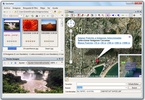
GeoSetter is a free Windows application that allows you to geolocalize your photos on a map by using GPS coordinates.
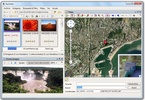
Geolocalizing a photo is as easy as selecting it and navigating through the map until you find its spot. The program takes care of gathering the map data and saving it into the image's metadata.
Advertisement
There are different types of maps - symbolic and graphic - thanks to Google Maps.
The program also lets you edit other image metadata, like, for example, date of creation.
GeoSetting can export to Google Earth and to Locr.









Comments
There are no opinions about GeoSetter yet. Be the first! Comment